The border guard took this picture of us just after achieving our goal to bike to Alaska!
Tonight we are in Tok, Alaska. Yesterday we crossed into the United States in a most remote location, on the Top of the World Highway. I have now entered my 49th state, and I plan to get #50 on the way home to Ohio when we drive through North Dakota. This was Bob's 50th and final state!
That's the border crossing over on the right of the photo. The ride to get there from Dawson City ranks up there with one of the most scenic bike rides I've ever taken. We were riding for 64 miles on the ridge of a mountain range, able to look off both directions for seemingly 100 miles on a perfectly clear and sunny day. In one view, an entire mountainside was lavender, because it was covered with wildflowers. Here's just ONE view I captured that day with my camera, but every two seconds we had a changing, most incredible scenery:
Day 26 July 10. Carmacks to Stewart's Crossing, Yukon. Distance 106 mi. My distance 20 mi.
Today's title is MOTORHOME MISHAP. After 46 miles, Bob was turning the RV around on a small side road, and he went beyond the asphalt and the soft shoulder collapsed under the weight of the motorhome. No matter what we did with the shovel, branches, and plastic squares to gain traction, the tires just kept sinking deeper into the soft shoulder dirt.
An electrician, Dave, from Whitehorse (180 miles south), who was applying for a job nearby, stopped to help. We finally decided we were NOT going to get the RV up onto the road, so Dave drove me back to the nearest city, which was where we had spent the previous night in Carmacks (46 miles), to find a tow service. Why not just call for a tow truck? No cell service there. Of course, none of the five of us have cell coverage in Canada, but the electrician did. But for phone coverage we had to head south. Here's a picture of Dave driving his 1990 truck with 200,000 miles on it:

In Carmacks, all three tow services were out of business! Next closest town? Whitehorse, another 120 miles south. Using Dave's cell phone, I called the established towing service, and their cost estimate was $1500!! (Six hours roundtrip, plus the actual winch pull to get us up onto the road.) I got a card for an upstart guy, called him, and he estimated $500. Do it! I waited 2 1/2 hrs for him without any ability to make sure he REALLY was on his way, but he showed up and we drove the hour north to the RV and the guys, who wondered why I had been gone so long. The police were there, with lights flashing. Exciting. Best, the towing guy DID pull us out! Check out this photo with the entire right front of the RV in the air:

By the time it was all over and done, it was 7 pm and we still had to drive 60 miles to our destination campground - which turned out to be OUT OF BUSINESS. What the heck? It had been raining for hours, and we just wanted to go to sleep. We parked in one of the RV sites that "used to be", the only people in the area, then baked two pizzas, took showers, and went to bed. It rained hard the entire night. It felt SO GOOD to be safe and cozy in the watertight motorhome! We slept until 8 am, two hours later than usual!
The day started back in Carmacks with a scrumptious breakfast at the campground restaurant.
I was the day's first driver, and heading out of town I crossed the wide and rushing Yukon River. Little did I know I'd be crossing that bridge four more times that day! When I caught up to the guys, they were stopping at a view spot 18 miles up the road. I wanted to get the same photo of the rapids in the Yukon River, but could not find my camera. I drove back to Carmacks and a good Samaritan at the restaurant had found it and turn it in!!
I later crossed over the bridge with Dave on our way back to Carmacks, and I was in the tow truck on my fifth crossing heading back up to the scene of the mishap.
Day 27 July 11. Stewart's Crossing to Dawson City. Distance 116 mi. My distance 72 mi.
It was still pouring rain in the morning as we drank our coffee (w/o being hooked up to electricity, and with the generator not working, we boiled water and used Nescafe instant). No one was too excited about starting a 116-mi ride in a downpour, so we decided to drive 15 miles to Moose Creek Lodge to see what the forecast was. The guy there said it was supposed to rain for a week. Oh no. We were pretty bummed. We knew that the next day (after Dawson City), the road was dirt, and a muddy road would have been difficult even in the RV. (We were SO glad his prediction was wrong, because the next day we had the most gorgeous weather on a day with spectacular views on the Top of the World Highway.)
Bob and I decided to ride and see how far we wanted to go depending on the conditions. The other three had a second breakfast in the rustic but welcoming cafe:
Because of the rain, I have no photos of the ride to Dawson City. It was getting late, so I finally gave up and got driven in the final 27 miles (Bob had stopped after 40 miles.) The rain stopped for our evening on the town in this historic, colorful gold rush town. It truly did fit exactly the image I had of an old western wild frontier, which in 1900 was the most populated town north of San Francisco. We all went to dinner and downed five huge platters of Chinese food (we shared), along with the rice and two pitchers of Yukon beer.
Then we went to the burlesque show! It's a gambling hall with three shows nightly, run as a not-for-profit by the local tourist association! Funny.
Here's us watching Diamond Tooth Gertie's floor show, after Bob and Derek played blackjack and I lost some coins in the slots. It was a night of fun!
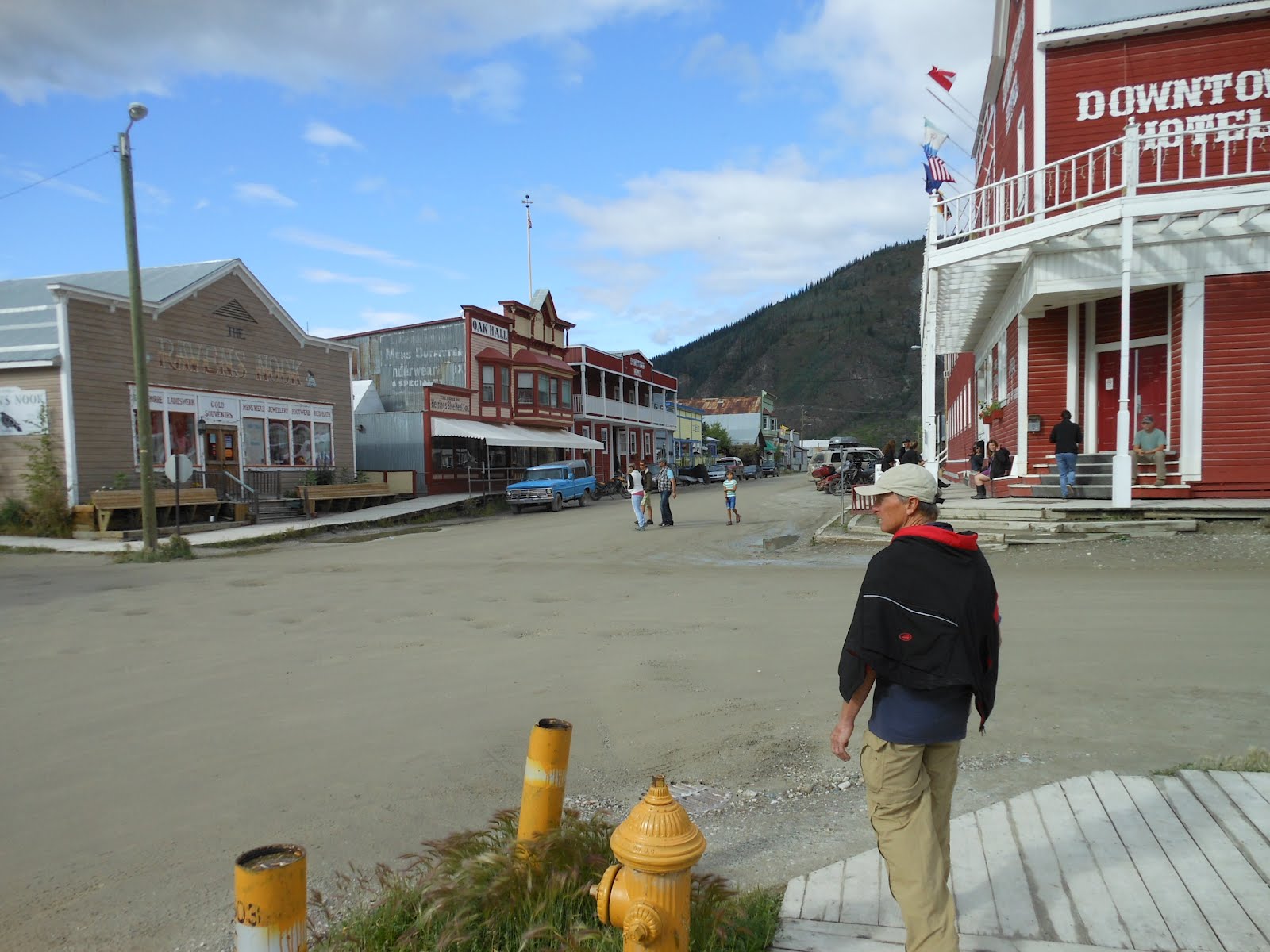
Dawson City was my favorite town so far. Unpaved, muddy streets with huge pot holes. Boardwalks, not sidewalks. Old original buildings and homes. Everything just FIT the image! Here's a photo of Bob, and you can see the potholed muddy street and the boardwalks.
We walked around town some, including along the banks of the Mighty Yukon.
Day 28 July 12. Dawson City, Yukon to Chicken, Alaska. Distance 114 mi. My distance 57 mi.
The day began by crossing the Yukon on a ferry boat. I had to stay in my vehicle, but I got this photo out my window:
This day was one of the most scenic in my life, as I said at the front of this posting. Riding along the ridge of a mountain range at approx 4000 ft elevation, seeing huge panoramic views both north and south, for 100 miles distant, was uplifting and exhilarating.
Eventually, we came to the final steep hill leading to the highest point along the highway, 4525 ft. It was a massive effort to climb that final hill, and then just a mile farther was the border crossing station. Here's a shot of me standing on the Alaska side of the border:
I like this shot of us:
The 64 miles to the border crossing while still in Canada (Top of the World Highway) had a road surface that was pretty bad, but at least most of it was paved; we had to slow way down over the long sections of gravel and dirt. But it was GREAT compared to how bad the gravel road was on the Alaska side, through all of the 46 mi to our destination of Chicken. I could barely ride, having to slow WAY down and negotiate through rocks and loose gravel and ruts and horrible surfaces. I finally gave up, loaded my bike onto the RV, and drove the final 30 miles. Only Bob went on, with his heavy touring bike meant for these kinds of roads. I had to drive the RV so slowly, and Bob was riding so fast, that it took us 26 miles to catch him. Bert and Derek finally decided to ride the final 15 or so miles too.
For me, it was a weird feeling giving up like that and getting sagged in, because it was the first time I'd ever (on a bike tour) given up when others were still riding. I'd stopped before, but only when I felt I should for the sake of others and our schedule. But in this case, Bob was going on, and I elected not to. It sort of ended the "romance" of my being able to hang in there regardless of conditions.
We finally arrived in the tiny settlement of Chicken. It consisted of three small components in this historic gold mining area: two RV parks, and "Downtown Chicken" (each owned by a different person in their population of 20).
Day 29. Today. Chicken to Tok. Distance 78 miles. My distance 58 mi.
Here's a photo showing how those in Chicken have fun with the name of their little stopover.
We had a hilly but nice ride to Tok today. Off in the distance we viewed the snow-capped Alaska Range mountains. Here's about the only photo I took today showing the "road ahead".
Once we got to Tok, we went shopping and got gas. It was so nice to pay $2 less per gallon than it cost in Canada. We stocked up on LOTS of needed groceries. And we all are spending hours in the campground office on our computers getting caught up on blogging, after the four nights without Internet.
We now turn southwest toward Anchorage in four days, when Janet gets to visit. I cannot wait, I've missed her so much, especially when we have no Internet service.


No comments:
Post a Comment